
First things first, please make sure that you are absolutely clear about the difference between Australian Mainland, Australasia, Micronesia, Melanesia, Oceania and Polynesia :

- Australia/ Australian Continent = Mainland Australia + Island of Tasmania

Oceania = Melanesia + Micronesia + Polynesia + Australasia (Basically Everything)
Australasia (a part of Oceania) = Australia/ Australian Continent + New Zealand + neighbouring islands in the Pacific Ocean

To sum it up :
Australian Mainland + Tasmania =  Australia

Australia + New Zealand + Small islands = Australasia

Melanesia + Micronesia + Polynesia + Australasia = Oceania (Add up every region)
Tip : Draw Venn Diagrams in your notebook to remember
If that part is clear, let’s proceed :
States and Territories of Australia
Australia = Federation of 6 states (5 on Mainland + Tasmania) + 2 Mainland Territories (ACT & NT)
- Queensland : Brisbane
- New South Wales : Sydney, Canberra (Australian capital territory)
- Victoria : Melbourne
- South Australia : Adelaide
- Western Australia : Perth
- Northern Territory : Darwin
- Tasmania : Hobart
*** States in Black, Territories in Red
** 7 States are shown and not 8 (6+2) as ACT is included in NSW
** The 2 mainland territories function as states, except that the Commonwealth Parliament has the power to modify or repeal any legislation passed by the territory parliament
**The places after the ‘:’ are the major cities in the state
** States are in the clockwise manner
** To remember the major cities, use the mnemonic BSC MA PhD (Ph is Perth).
** Remember Tasmania with its major city as Hobart too !!!

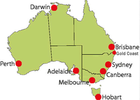
Notice that all the major cities are on the sea coast. WHY?
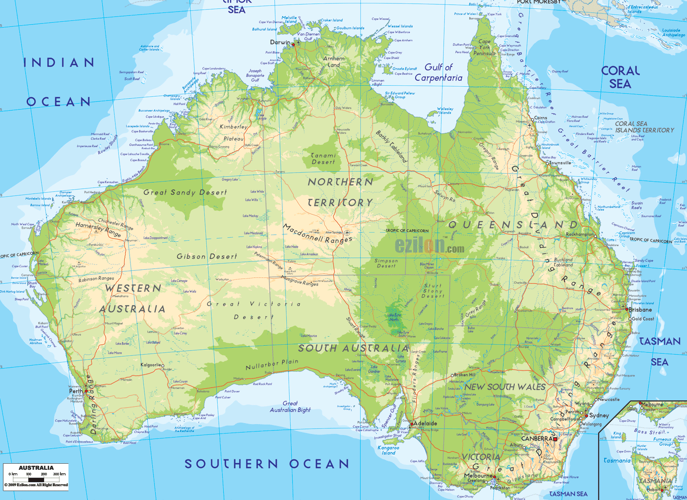
Observe a few points about Australia from the map
- More than 1/3rd of the country lies within the Tropics (extends from 10° S – 45ºS )
- A portion of the South Pacific known as the Tasman Sea separates Australia and New Zealand
- Tasmania is separated from mainland Australia by the Bass Strait and is the smallest state in Australia (Western Australia being the largest)
Now that you have a basic understanding of the map of Australia, open your Atlas or Google Maps and locate the following places:
- Gulf of Carpentaria : (Boundary of NT and Queensland)

- Joseph Bonaparte Gulf : (Boundary of WA and NT)

- Torres Strait : Separates Australia and Papua New Guinea (specifically the state of Queensland)
- Bass Strait : Separates Tasmania from the Australian mainland (specifically the state of Victoria)
- Murray and Darling rivers
- Great Barrier Reef: located in the Coral Sea, off the coast of Queensland
- Coral, Timor and Tasman sea
- Great Australian Bight
- Spener gulf
- Great Dividing Range : How it affects the climate of the region?
- Shark Bay
- Gold Coast : Connect with the Commonwealth games – 2018 !!!
- Archipelago of the Recherche (Group of 105 islands)

If you find it difficult to remember the locations, just draw the map on your notebook and label the places that you remember. After labelling all the places you could remember at that time, locate the ones that you could not using the atlas.
Repeat it 5-6 times and you are done.
Happy Learning 🙂
